Arta
Capital: Arta
Main areas are: Arta, Kataraktis, Koronissia.
One of the most beautiful areas of Greece, the prefecture of Arta is one of the four prefectures of the periphery of Epirus. It is bounded by the mountain range of Tzoumerka and the Ambracian Gulf.
Its landscape combines the rugged beauty of the Greek mountains along with the shallow-water beaches of the Ambracian Gulf and the fertile valley of Arachthos river.
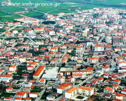
Arta is built on the ruins of the ancient town of Ambracia, on the left bank of Arachthos river and it climbs amphitheatrically to the northwest foot of the hill, which, from the ancient days until today, is called Peranthi .
The city is well known for its Byzantine churches, its castle, its clock, important neoclassical buildings and, above all, the symbol of the city, its legendary Bridge, famous not only for its architectural value, but also for the myth of the sacrifice of the master builder’s wife.
Arta is home to the Epirus Technical Educational Institute (TEI) . The pride of the city is the women’s handball team, holder of the Greek Championship for many years.
There are many Cultural Clubs, Sports Clubs, an Open-air Theatre in the Castle, a Historic and Folk Art Museum, churches as well as an Exposition Centre.
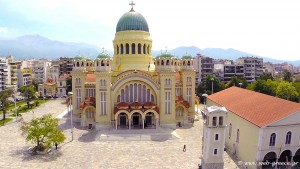
Besides the famous Bridge , an other important attraction in Arta is the Byzantine Church of “Panagia Paregoritissa ” (dedicated to the virgin Mary, the “Consoler”). This is a grandiose temple, dedicated in memoriam of the Annunciation of Virgin Mary. It was built within the years 1283 to 1296 A.D. by the ruler of Epirus Nikephoros I Komnenos Doukas.
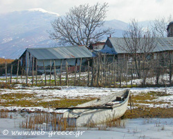
The Ambracian Gulf is one of the most important and largest wetlands in Greece and it is protected by international Conventions such as of Ramsar, Vienna etc. It consists of the double delta of the rivers Louros and Arachthos and the lagoons of Rodia, Logarou, Tsoukalio and Agrilou . Its surface area is estimated at 32.150 acres and its morphology is very interesting due to the interspersion of land and sea areas.
In the wetlands of Ambracian Gulf there is a great variety of flora, amphibious species and it is shelter for 250 species of birds , some of which are extremely rare (collared pranticola, black-winged stilt, stone curlew, purple heron, white-tailed sea eagle, booted eagle, hobby etc.). A small island in Tsoukalio lagoon is inhabited by one of the few remaining in Europe pure populations of dalmatian pelican (Pelecanus Crispus).
Koronissia
The ancient settlement of Orraos , one of the four towns of Mollosses which was destroyed by Romans in 168 B.C., is in the location called “Kastri ” of Ammotopos and it dates back to the 4th century B.C. The settlement was surrounded by a strong wall which later was fortified with towers. Remains of many stone-built houses are to be found today.
Neochori
Of archaeological interest is the church of Agia Theodora in the village Sykies
The Bridge of Plaka connects the banks of Kalarrytikos river, a tributary of Arachthos . It can be found on the road to Agnanta area, a short distance from the bridge vehicles use today. It was built in 1866 by the master builder Konstantinos Bekas. It is 40 m. long and 20 m high at its highest point. It used to be the border between the Turkish and the Greek countries between the years 1881 and 1913. Today it is the stating point for kayaking or rafting rides in an Arachthos route to the village Skoupa.
The village Katarraktis
The Castle of Arta was built in the 13th century B.C. on a part of the ancient wall. Today inside the Castle you can find an open-air municipal theatre, one of the best of its type in Greece, where important cultural events take place.
Vourgareli
It is a village with lush vegetation, running waters and stone-built houses with ceramic roofs. It is a tourist point of attraction and it can also serve as a base to excursions in the surrounding area.
By car: Via the national roads of Ioannina – Arta, Preveza – Arta, Antirrion – Arta.
The distance from Athens is 370 km.
By bus: There is regular KTEL bus service from and to Athens, Patras, Ioannina, Preveza and Igoumenitsa. There is also frequent bus service to and from Trikala, Filippiada, Agrinio etc.
By plane: You can get here via the airports of Ioannina and Preveza.
Arta Municipality
26813 62100
Thessaloniki Bus Station
2310 595406
Arta Hospital
26810 77222
Arta Taxi Station
26810 78333
Arta Police Station
26810 21450, 21470
Arta Urban Bus Station
26810 28314
Arta Traffic Police
26810 21464, 21466
Arta Post Office
26810 22422
Arta Fire Station
26810 27333
Parigoritissa Museum
26810 28692
Arta Bus Station
26810 27348
Arta Historical Museum
26810 27345
Athens Bus Station
210 5134866
Arta Folklore Museum
26810 22192