Thesprotia
Capital: Igoumenitsa
Also the mainer regions are: Igoumenitsa, Souli, Sivota.
The prefecture of Thesprotia is one of the four prefectures in the periphery of Epirus. It is characterized by picturesque mountainous regions as well as beautiful seaside areas. It is situated on the NW end of Epirus by the Albanian borders and it is bathed by the Ionian sea.
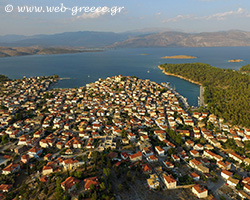
The seat of the prefecture is the city of Igoumenitsa, called “the gate of Greece to Western Europe” due to its important port. The prefecture also includes some important towns, which are the commercial and administrative centers of their surrounding areas. Some of them are Sivota, Perdika, Paramythia, Filiates, Sagiada, Plataria, Souli etc.
Ελλάδα
The impressive feature of the prefecture is the enchanting shoreline from Sagiada up to the mouth of Acheron river. Beaches with turquoise waters, golden sand or white pebbles, quiet bays surrounded by green landscapes and small picturesque ports. Thesprotia is certainly a place worth visiting to enjoy the beauty nature has endowed it with.
The city of Igoumenitsa
It name is probably due to an abbot (“igoumenos” in Greek) of a monastery that used to be there. The historian Thucydides named the port «Limin Erimos» (Deserted port). The city was freed from the Turkish occupation during the First World War (1913).
The points of interest in the city include the Municipal Library and the Municipal Art Gallery as well as the tower of Rayios built on a 85m hill, 3 km from the beach of Drepanon of Igoumenitsa. This tower protected the settlement of the peninsula of Lygia. Today, from the walls remain parts of 5m height and 3,7 m wide. Do not omit to visit the Hellenistic settlement of Gitani , the of Javellena (heroine from Souli), as well as the Delta of Kalamas river, a wetland with high ecological value.
The combination of mountain and sea, the charms of the city and the endless golden-white beaches can enchant every visitor. Τhe long clear-water beaches of Drepano and Makrigialos , 7 km long, offer tranquility, rest, good food and an ideal vacation for all visitors. In the last years these two beaches are awarded with the Blue Flag eco-label.
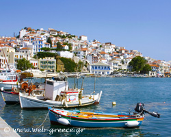
Sivota Mourto , while the name Sivota was adopted in 1959.
Sivota is built in an idyllic landscape by an enchanting bay surrounded by hills, with small green islands, exquisite beaches with crystal clear water. It is no wonder that the village is a center of attraction for thousands of tourists from Greece and abroad. In the recent years, Sivota has become an important summer destination for tourists. The beautiful beaches of Bella Vraka, Mega Ammos, Mikri Ammos, as well as the well organized marina, attract thousands of visitors every year.
You can visit the archaeological site of Dimokastro with the ruins of the ancient settlement of Elina. Also worth seeing is the village Perdika
Paramythia
There are many different views on the origin of its name, however the most accepted is that it is derived from the name of the monastery “Parigoritria ” (” Paramythia ” in ancient Greek), that existed in Paramythia. Right by the town flows the small river Kokitos , which is known from the ancient times as formed by the tears of the relatives of the dead people that Charon took to Hade s on his boat.
Overlooking the town, the fortress of Ai Donatos rises majestically on a naturally protected site. Its name comes from the church in the fortress with the same name, which was dedicated to Donatos , bishop of Evia (4th century A.D.).
These days the town throbs with life. Its geographical position and the fertile plain are the motive power for its growth. The modern highway Egnatia Odos (Via Egnatia) will connect it to the main part of Greece and give a further push to its growth.
You can visit the ruins of the ancient town Fotiki
Sagiada
Walking on the old trails and the stone-paved narrow streets, you can visit the Delta of Kalamas River which is an ecosystem with interesting species of fauna and flora, attracting many researchers from around the world.
The area of Filiates
These days, Filiates is a well organized municipality with all the necessary infrastructure and services needed for its operation. The area is very rich in natural beauty and also in sites of archaeological interest such as the ruins of the ancient city Titani , the monastery of Giromerion , the Tsamadas folk art museum etc. Some of the settlements of the municipality have been characterized as ” Traditional settlements “, such as Giromerion, Faneromeni, Kamitsani, Plesio Finikio
Perdika is in the southernmost end of the prefecture of Thesprotia, opposite the southernmost part of the island of Corfu. It is an olive-oil producing village with increased tourist appeal, mainly due to the nearby beaches bathed by the turquoise waters of Ionian sea. The sunset at Perdika is something you would not want to miss either. In the summer the sun sets right in front of the village, behind the island of Corfu. At night the lights from Corfu, the island of the Phaeacians and nearby Sivota make for an interesting sight that can keep you looking at for a long time.
Souli
The municipality of Margariti
The area (sites Morfi, Mazarakia etc.) is rich in findings from the Middle Paleolithic era (stone tools etc.) and it seems that it is one of the areas of Thesprotia where Paleolithic man has lived.
By car: You can drive to Thesprotia via the national routes: Ioannina – Igoumenitsa, Preveza – Igoumenitsa
From Athens the distance is 475 km
By bus: There is bus service of the KTEL from Igoumenitsa, Athens, Thessalonica, Patras and other big towns.By air: There is airline service from Aktio and Preveza’s airport.
Igoumenitsa Municipality
26653 61100
Igoumenitsa Fire Station
26650 23202, 21408
Igoumenitsa Health Center
26650 24420, 28346
Igoumenitsa Bus Station
26650 22309
Igoumenitsa Police Station
26650 29665
Athens Bus Station
210 5125954
Igoumenitsa Traffic Police
26650 29622, 22196
Thessaloniki Bus Staion
2310 517188
Igoumenitsa Tourist Police
26650 21200
Igoumenitsa Taxi
26650 23200, 23500
Igoumenitsa Port Authority
26650 99400
Igoumenitsa Archaeological Collection
26650 28411